A building in Kitengela develops wide cracks six months after completion. The walls split vertically. The floor slab heaves. The owner calls a structural engineer. The structural engineer calls a geotechnical engineer. The verdict: black cotton soil. Nobody tested the ground before construction. The foundation was never designed for the actual soil conditions on site. The result is a building that must be partially demolished and rebuilt from the foundation up.
This scenario plays out repeatedly across Kenya’s satellite towns — Syokimau, Athi River, Ruiru, Ngong, Juja, Kamulu, and dozens of others where black cotton soil sits just beneath the surface. In every case, the cost of a proper geotechnical field investigation before construction would have been a fraction of the repair bill that followed. Cadreatech conducts geotechnical field investigations for building projects across Kenya. Every investigation follows BS 5930:2015 — the Code of Practice for Site Investigations — and produces a factual report and engineering interpretation that gives the structural and civil design team everything they need to design the correct foundation from the start.
🔍 Kenya National Building Code requirement: A geotechnical investigation report is required for all multi-storey buildings, large commercial developments, and projects on sites with known difficult ground conditions. The NCA and county authorities require this report as part of the building plan approval submission. Cadreatech prepares both the field investigation and the engineering interpretation report to the standard required for regulatory approval.
Why Geotechnical Field Investigations Are Non-Negotiable in Kenya
Kenya’s ground conditions vary dramatically — sometimes within a single plot. Nairobi alone sits on volcanic pyroclastic rocks, agglomeratic tuffs, silty clays, and black cotton soils. The University of Nairobi’s study on Nairobi’s subsurface geology found that ground conditions vary significantly over short distances. Constructors have reported highly variable subsoil at sites just metres apart. This variability means desktop assumptions about soil conditions are unreliable. Only a physical investigation of the specific site gives you the data you actually need.
Beyond Nairobi, conditions become even more complex. The Kenyan coast presents coral limestone, marine clays, and highly variable fill. The Rift Valley brings volcanic ash, collapsible soils, and geothermal activity. The Highlands offer good red volcanic soils in some areas and problematic expansive clays in others. Furthermore, areas like Kiambu, Machakos, Kajiado, Kisumu, and the Trans Mara have extensive black cotton soil coverage — some of the most challenging ground in the country for construction.
Each of these ground conditions demands a different foundation solution. The only way to know which applies to your site is to investigate it. Cadreatech’s geotechnical field investigation programme identifies exactly what sits below your building — and what your structural engineer must design the foundation to resist.
Kenya’s Soil Types and Why They Matter for Your Foundation
Understanding the soil beneath your site is the first step to designing a safe, economical foundation. The following soil types appear most frequently in geotechnical investigations across Kenya.
Black Cotton Soil — Kenya’s Most Challenging Ground
Black cotton soil — also known as expansive soil or Vertisol — is one of the most problematic soils in Kenya for construction. It is found extensively across Kitengela, Syokimau, Athi River, Ngong, Juja, Ruiru, Kamulu, Kajiado, Machakos, Kisumu, and parts of the Rift Valley. When it absorbs water during the rainy season, it swells significantly. When it dries out, it shrinks and cracks. This cycle of expansion and contraction exerts enormous pressure on foundations.
The consequences are severe. Buildings on poorly designed foundations in black cotton soil develop wall cracks, floor heave, differential settlement, and in extreme cases, structural failure. The bearing capacity of black cotton soil is poor — typically 50–100 kN/m² depending on moisture condition — compared to well-compacted red soil or rock, which can support 200–500 kN/m² or more. Consequently, every foundation in black cotton soil requires specific engineering design based on investigation data. A strip footing that works perfectly in Kiambu highlands red soil will fail within years in Kitengela black cotton.
Red Volcanic Soils — Kenya’s Best Construction Ground
Red volcanic soils are found across the central highlands — Murang’a, Nyeri, parts of Kiambu, and other areas of volcanic origin. These soils are generally stable, well-draining, and offer good bearing capacity for construction. They are the preferred ground for construction in Kenya. However, even red volcanic soils vary in depth, consistency, and bearing capacity across a single site. Furthermore, weathered zones within otherwise good red soil can create localised weak layers that cause differential settlement if not identified during investigation.
Volcanic Ash and Tuff — Nairobi’s Unique Challenge
Much of the Nairobi subsurface consists of pyroclastic volcanic rocks — tuffs, agglomeratic tuffs, and volcanic ash deposits. These materials present unique engineering challenges. Some layers are hard and offer excellent bearing capacity. Others are soft, highly compressible, or moisture-sensitive and collapse under load when saturated. According to the University of Nairobi subsurface study, distress is common in structures supported on concealed fractures and moisture-sensitive volcanic soils in the city. Without a proper investigation, a foundation can unknowingly sit on a weak volcanic ash layer just below the surface.
Coastal Soils — Mombasa and the Kenyan Coast
The Kenyan coast presents a completely different set of ground conditions. Coral limestone, marine clays, beach sands, and made ground from historic coastal development all appear in coastal investigations. Coral limestone can be highly variable — solid rock in one borehole, cavities and weak zones in the next. Marine clays have very low bearing capacity and high compressibility, making pile foundations the standard solution for significant structures in coastal areas. Cadreatech conducts geotechnical investigations for coastal projects across Mombasa, Kilifi, Malindi, Diani, and Lamu.
Collapsible and Fill Soils
Some sites in Kenya sit on made ground — areas previously used for dumping, filling, or agricultural activity. Collapsible soils appear in some areas of the Rift Valley and certain volcanic zones. These soils behave normally under dry conditions but collapse suddenly under load when saturated — with no warning. A geotechnical investigation identifies collapsible soil immediately. Building on it without this knowledge risks catastrophic foundation failure when the rains arrive. Cadreatech’s investigation programme always includes specific tests for collapse potential where the geology suggests risk.
The Cadreatech Geotechnical Field Investigation Programme
Every Cadreatech geotechnical investigation follows a structured programme designed to characterise the site thoroughly. The programme begins with a desk study and ends with a detailed factual report and geotechnical design recommendations. Between these two points, a series of field tests and laboratory analyses build a complete picture of what sits below your site.
Desk Study and Site Reconnaissance
Before a single borehole is drilled, Cadreatech conducts a desk study. This reviews available geological maps, historical borehole records, aerial photographs, and any existing information about the site and its surroundings. The desk study identifies potential risks — known problem soil zones, historic landfill areas, high water table zones, and areas with known subsurface variability. It also informs the field investigation programme — determining how many boreholes are needed, how deep they should go, and what tests are most appropriate for the anticipated ground conditions.
Site reconnaissance follows the desk study. A geotechnical engineer visits the site to observe surface conditions, drainage patterns, existing structures, any signs of previous instability, and the general topography. This visual assessment provides information that no map or database can replace. Furthermore, it allows the investigation programme to be refined before mobilisation — saving time and cost on site.
Exploratory Borehole Drilling
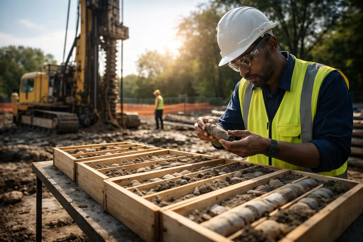
Borehole drilling is the primary method of subsurface investigation. A drilling rig advances a borehole into the ground, recovering soil samples at regular intervals. These samples tell the engineer what soil or rock type exists at each depth, its colour, consistency, and structure. The borehole log — the record of what was found at each depth — is the primary factual output of the investigation.
Cadreatech conducts borehole drilling using rotary core drilling rigs equipped with continuous flight augers for soil overburden and diamond core bits for rock. All fieldwork complies with BS 5930:2015 and incorporates ASTM D1586 procedures for SPT testing. Borehole depths range from 5m for simple residential projects to 25m or more for high-rise commercial buildings, bridges, and infrastructure on difficult ground. The number and layout of boreholes depends on the building footprint, the number of storeys, and the anticipated variability of the ground.
Standard Penetration Testing (SPT)
The Standard Penetration Test (SPT) is the most widely used in-situ test in geotechnical engineering worldwide — and the most relied upon in Kenya. The test drives a standard split-spoon sampler into the soil at the base of the borehole using a standard hammer and drop height. The number of blows required to drive the sampler 300mm into the ground is the SPT N-value.
The SPT N-value directly indicates the soil’s relative density and consistency. It also provides the primary data for calculating allowable bearing capacity — the maximum load per unit area that the soil can safely support without excessive settlement. SPT N-values are used in the Terzaghi-Peck relationship and Meyerhof’s empirical formula to calculate bearing capacity values at each depth in the borehole. For a recent apartment development in Kiambu County, for example, SPT N-values ranged from 16 at 1.5m depth (stiff soil, 116 kN/m²) to 31 at 4.5m depth (very stiff soil, 224 kN/m²). These figures determine the recommended foundation depth and bearing pressure for the structural design.
All SPT tests in Cadreatech investigations are carried out at 1.5m intervals throughout each borehole — giving a continuous profile of soil strength from surface to the full investigation depth. Results are tabulated and presented in the factual report alongside the borehole log.
Trial Pits
Trial pits are shallow excavations — typically 1.5 to 3m deep — that allow direct visual inspection of near-surface soils. Unlike boreholes, which provide a narrow cylindrical sample, a trial pit exposes a full face of ground. This allows the engineer to observe soil layering, identify fill materials, examine root penetration and topsoil depth, and assess drainage conditions directly. Trial pits are particularly valuable on sites where near-surface conditions are expected to be complex or variable, and for small residential projects where full borehole drilling may not be economical.
Cadreatech records trial pit logs with photographs, depth measurements, soil descriptions, and any features of engineering significance — such as the presence of fill, loose material, or organic matter. On sites with suspected black cotton soil, trial pits allow the engineer to measure the depth of the expansive layer and assess whether excavation and replacement or a more engineered foundation solution is needed.
Cone Penetration Testing (CPT)
The Cone Penetration Test pushes a instrumented cone into the ground at a controlled rate, measuring tip resistance and sleeve friction continuously as a function of depth. Unlike SPT, which gives a value every 1.5m, CPT provides a virtually continuous profile of soil strength from surface to the test depth. This makes CPT ideal for sites where thin weak layers — the kind that cause differential settlement — might exist between SPT test intervals.
CPT is particularly valuable in coastal and deltaic environments, in areas with soft clays, and on sites where the presence of thin compressible layers is suspected. The continuous profile also allows accurate identification of soil layer boundaries and transitions — information that the structural engineer needs to design a foundation that performs consistently across the full building footprint.
Groundwater Measurements and Monitoring
Groundwater depth affects foundation design in several important ways. A high water table reduces the effective stress in the soil — and consequently reduces its bearing capacity. It also creates buoyancy forces on basement slabs and retaining walls. It affects excavation stability and determines whether dewatering will be needed during construction. Furthermore, groundwater chemistry can affect concrete and steel reinforcement through sulphate and chloride attack.
Cadreatech measures groundwater levels at the completion of each borehole and installs standpipe piezometers where long-term monitoring is required. Water samples are taken where chemical analysis is needed to assess concrete aggression potential. Groundwater results are presented in the factual report and interpreted in the design recommendations — informing decisions on foundation type, basement waterproofing, concrete specification, and drainage system design.
In-Situ Density and Permeability Tests
In-situ density tests — using sand replacement or nuclear density methods — measure the density and compaction state of fill and near-surface soils. These tests are important where existing fill is present on site, or where compacted material is used to replace excavated poor soil. They confirm whether the material in place meets the compaction standard required for the intended foundation loading.
Permeability tests in boreholes — using falling head or rising head methods — measure how quickly water moves through the soil. This information is critical for drainage system design, for assessing the feasibility of soakaways and infiltration systems, and for evaluating the risk of groundwater ingress into basements during construction and in service. It is also essential for specialist systems such as biodigesters and soakage pits, where soil permeability determines whether the system will function correctly.
Vane Shear Testing
The vane shear test measures the undrained shear strength of soft, cohesive soils — clays and silts — directly in the borehole. It is particularly useful in coastal areas with soft marine clays and in lacustrine deposits around Lake Victoria and other water bodies. The undrained shear strength is the key parameter for assessing the short-term stability of excavations in clay, for pile capacity calculations in soft ground, and for assessing the risk of slope instability on waterlogged sites.
Laboratory Testing of Soil and Rock Samples
Field tests tell the engineer what the soil looks like and how stiff it is. Laboratory tests reveal its fundamental engineering properties — the parameters that go into foundation design calculations. Cadreatech sends samples from every investigation to a KEBS-accredited geotechnical laboratory for the following tests.
Particle Size Distribution and Atterberg Limits
Particle size distribution — the grading test — separates the soil into its constituent particle sizes: gravel, sand, silt, and clay fractions. This classification determines the soil’s basic behaviour and its susceptibility to frost, settlement, and permeability changes. Atterberg limits — the liquid limit and plastic limit — measure the moisture contents at which a cohesive soil transitions between liquid, plastic, and solid states. These tests identify expansive clays, determine the plasticity index, and are essential for classifying black cotton soil and other problematic fine-grained soils.
Moisture Content and Bulk Density
Natural moisture content measures how much water the soil currently contains. Combined with bulk density measurements, it gives the engineer the effective stress state of the soil at the time of investigation — and allows assessment of how the soil’s behaviour will change as conditions vary during construction and in service.
Direct Shear and Triaxial Shear Tests
Shear strength tests measure the soil’s resistance to sliding failure under load. The direct shear test applies a horizontal force to a soil sample while measuring the force required to cause shearing failure. The triaxial test applies controlled confining pressure and axial load to a cylindrical sample, measuring failure under conditions that simulate actual foundation loading. These tests provide the cohesion and friction angle values that go directly into bearing capacity calculations and slope stability analyses.
Consolidation and Settlement Tests
The consolidation test compresses a soil sample under incremental loads, measuring the rate and magnitude of compression over time. This gives the engineer the coefficient of volume compressibility — the key parameter for calculating how much a structure will settle over time under its design load. Settlement calculations are critical for high-rise buildings, bridges, and any structure where differential settlement between adjacent foundations could cause structural damage or serviceability problems.
Point Load and Uniaxial Compressive Strength Tests
Where rock is encountered during borehole drilling, rock cores are recovered and tested in the laboratory. Point load tests and uniaxial compressive strength (UCS) tests measure the rock’s strength. Rock Quality Designation (RQD) — a measure of core recovery — assesses the degree of fracturing. These parameters determine the allowable bearing capacity of rock foundations and inform the design of rock socketed piles where the structural load must be transferred through weak overlying soil to competent rock below.
Sulphate and Chloride Content
Elevated sulphate or chloride concentrations in soil and groundwater attack concrete and steel reinforcement. Sulphates cause concrete to expand and crack — sulphate attack. Chlorides cause corrosion of steel reinforcement — particularly critical in coastal areas and near industrial waste sites. Cadreatech analyses soil and water samples for sulphate and chloride content on all projects. Where aggressive conditions exist, the concrete specification is upgraded to sulphate-resisting cement or higher cover to reinforcement — preventing long-term deterioration of the foundation before it begins.
The Geotechnical Investigation Report
The output of every Cadreatech field investigation is a comprehensive geotechnical investigation report. This report has two parts. The factual section presents the raw data — borehole logs, SPT results, trial pit records, laboratory test results, groundwater data, and photographs. The interpretive section translates this data into engineering recommendations that the structural and civil design team can use directly.
What the Report Contains
- Site description and geology: Location, topography, existing structures, surface drainage, and the regional and local geology relevant to the site.
- Field investigation methodology: Number and location of boreholes and trial pits, drilling equipment used, standards followed, and dates of fieldwork.
- Borehole logs: Detailed logs for every borehole, showing soil description, depth of layer boundaries, SPT N-values, groundwater observations, and sample locations.
- Laboratory test results: Tabulated results for every test carried out, with reference to the applicable test standard.
- Bearing capacity calculations: Allowable bearing pressure recommendations at specified depths for the anticipated foundation type and building loads.
- Foundation recommendations: Specific recommendations on foundation type, depth, and bearing pressure — whether strip footings, pad foundations, raft foundations, or piles are most appropriate for the site conditions.
- Settlement assessment: Estimated settlement under design loading and assessment of differential settlement risk between adjacent foundations.
- Groundwater and drainage recommendations: Groundwater depth, seasonal variation, chemical aggressiveness, and implications for basement design and dewatering.
- Excavation and earthworks recommendations: Guidance on safe excavation slopes, shoring requirements, fill specification and compaction requirements, and disposal of any contaminated or unsuitable material.
- Concrete specification: Recommended concrete class and cement type based on sulphate and chloride test results.
This report is submitted to the NCA and county authorities as part of the building plan approval package. It informs the structural engineer’s foundation design. Furthermore, it is referenced throughout the construction phase to verify that actual ground conditions match those encountered during investigation.
How Geotechnical Investigations Connect to the Full Design Process
A geotechnical investigation does not stand alone. Its findings feed directly into every other engineering discipline on the project. The structural engineer uses bearing capacity recommendations to design pad footings, strip foundations, raft slabs, or pile caps. The civil engineer uses groundwater data and permeability results to design drainage, soakage, and slope stabilisation systems. The architect uses foundation depth recommendations to plan basement levels and ground floor slab construction details.
At Cadreatech, geotechnical investigation is part of our integrated engineering service. The geotechnical engineer, structural engineer, and civil engineer work from the same dataset — in the same firm. There are no delays waiting for one consultant to pass information to another. There are no interpretation gaps between the investigation report and the foundation design. The investigation findings are translated directly into the structural and civil designs — with the geotechnical engineer available to resolve questions as they arise during design development.
🏗 Cadreatech in the field: Cadreatech has conducted geotechnical investigations for residential, commercial, and infrastructure projects across Nairobi, Kiambu, Kajiado, Mombasa, Kisumu, and the wider Kenya region. Our field investigation programmes have informed foundation designs for apartment developments, commercial office buildings, hotels, schools, and civil infrastructure projects. View our project portfolio to see the range of investigations and structures we have supported.
Common Foundation Problems in Kenya That Geotechnical Investigations Prevent
The following foundation failures are among the most common in Kenya. Every one of them is preventable with a proper geotechnical investigation before construction.
Wall Cracking from Differential Settlement
Differential settlement occurs when one part of a building settles more than another. It causes diagonal cracking in walls — typically at window and door corners — and can eventually make a building structurally unsafe. The most common cause is a foundation sitting across two different soil types without the engineer knowing. One part sits on stiff soil or rock. The other sits on soft fill or black cotton soil. The investigation identifies this variability before construction. The engineer then designs a foundation that bridges the difference — eliminating differential settlement before it starts.
Foundation Heave from Expansive Soils
Heave is the upward movement of a foundation caused by soil expansion. It is the opposite of settlement — and in some ways more damaging, because it pushes the structure upward unevenly. Heave from black cotton soil is the most common cause of floor cracking and door frame distortion in Kenya’s residential buildings. A geotechnical investigation identifies the depth and plasticity of the expansive layer. The structural engineer then designs the foundation to either sit below the active zone or to resist heave forces — eliminating the problem entirely.
Collapse of Shallow Excavations
Excavations in soft or saturated ground can collapse without warning. This risk is highest in coastal marine clays, in saturated black cotton soil, and in made ground with loose or variable fill. A geotechnical investigation identifies these risks before excavation begins. The engineer specifies the correct excavation slope angle, shoring system, and dewatering arrangement — protecting workers and adjacent structures from excavation collapse.
Concrete Deterioration from Aggressive Ground
Sulphate-bearing soils and chloride-rich coastal groundwater attack concrete and corrode reinforcement. This deterioration is invisible for years — until the structure begins to show signs of distress. By then, the damage is extensive and expensive to repair. A geotechnical investigation with soil and water chemistry testing identifies aggressive ground conditions before construction. The engineer specifies the correct concrete class and cement type — preventing deterioration before the first pour.
Geotechnical Investigations for Diaspora Property Owners
Building in Kenya from abroad? Geotechnical investigation is one of the easiest corners to cut — and one of the most expensive to have cut badly. A contractor who skips the investigation and proceeds on assumption may save you KES 150,000–300,000 in investigation costs. However, the same contractor may then build a foundation on black cotton soil using a strip footing designed for red soil. The repair cost when the building cracks is typically ten to fifty times the cost of the investigation that was skipped.
Cadreatech conducts the investigation and prepares the report with full supporting documentation. You receive the borehole logs, SPT data, laboratory results, bearing capacity calculations, and foundation recommendations — all in one package. Combined with our construction supervision service, we verify that the foundation is built exactly as designed — at the depth, width, and bearing stratum specified in the investigation report. You receive photographic and written records of every key foundation stage before the excavation is backfilled and the evidence is buried.
Standards and Regulations Governing Geotechnical Investigations in Kenya
| Standard / Code | What It Covers | Applied By Cadreatech For |
|---|---|---|
| BS 5930:2015 | Code of Practice for Site Investigations | All field investigation programmes |
| BS 1377 | Methods of Test for Soils for Civil Engineering Purposes | All laboratory testing |
| ASTM D1586 | Standard Penetration Test (SPT) Procedure | All SPT testing in boreholes |
| Eurocode 7 (EC7) | Geotechnical Design | Foundation design recommendations |
| BS 8004 | Code of Practice for Foundations | Foundation type and depth recommendations |
| Kenya National Building Code 2022 | Minimum requirements for site investigation | NCA and county authority submissions |
| NCA Registration Requirements | Qualified engineer sign-off on investigation reports | All investigation reports submitted for approval |
Frequently Asked Questions on Geotechnical Investigations in Kenya
How much does a geotechnical investigation cost in Kenya?
The cost of a geotechnical investigation depends on the specific conditions of your site. Key factors include the number of boreholes required, the depth of investigation, the number of laboratory tests, and the site location. In every case, the investigation cost is a small fraction of the foundation construction cost — and a tiny fraction of the cost of repairing a building with a failed foundation. Contact Cadreatech for a site-specific investigation proposal.
How many boreholes does my site need?
The number of boreholes depends on the building footprint, the number of storeys, and the anticipated variability of the ground. As a general guide, a minimum of two boreholes per building is recommended for small residential developments. Larger buildings need one borehole per structural grid line intersection or per major load-bearing element. On sites with known difficult or variable ground, more boreholes are needed to capture the variability adequately. Cadreatech recommends the appropriate investigation programme for each project based on the desk study findings and the structural loading requirements.
How deep should boreholes go?
Borehole depth depends on the building type and the anticipated foundation depth. As a minimum, boreholes should extend to at least 1.5 times the width of the largest foundation element below the foundation level. For a typical residential building on strip footings at 1.2m depth, a borehole to 6–8m is often sufficient. For a multi-storey building on pad foundations or piles, boreholes to 15–25m are typically needed to characterise the full zone of influence of the foundation loading. Where rock is encountered, the borehole should extend at least 3m into competent rock to confirm its quality and continuity.
Is a geotechnical investigation required by law in Kenya?
Yes — for most commercial, institutional, and multi-storey buildings. The Kenya National Building Code 2022 requires geotechnical investigation reports for buildings above a specified height and for buildings on sites with known difficult ground conditions. The NCA and county building departments require the investigation report as part of the building plan approval submission. Buildings constructed without a required investigation report cannot receive a certificate of occupancy.
Can a geotechnical investigation be done after the building is designed?
Technically yes — but it is significantly more expensive and less effective than investigating before design. If the investigation reveals ground conditions that are different from the assumptions used in the design, the structural and civil designs must be revised. This revision costs more than designing correctly from the start. In some cases, the investigation reveals conditions so different from the assumptions that the building layout itself must change. Cadreatech always recommends conducting the geotechnical investigation before structural design begins — giving the engineer the real site data from day one.
What is the difference between a factual report and an interpretive report?
A factual report presents the raw data from the investigation — borehole logs, SPT results, laboratory test data, and groundwater measurements — without engineering interpretation. An interpretive report takes this data and translates it into engineering recommendations — bearing capacity values, foundation type, depth, settlement estimates, concrete specification, and earthworks guidance. Cadreatech produces both as a combined document. The factual data is presented first, followed by the engineering interpretation and design recommendations. This combined report is the document submitted for regulatory approval and used by the structural and civil design team.
Ready to Investigate Your Site?
Do not design a foundation on assumptions. The ground beneath your site is unique — and the only way to know what it is capable of supporting is to investigate it properly. Cadreatech conducts geotechnical field investigations for projects of all sizes across Kenya — from single residential plots to large commercial, industrial, and infrastructure developments.
Every investigation is conducted to BS 5930:2015, reported to the standard required for NCA and county authority approval, and interpreted by qualified geotechnical engineers who also provide the structural and civil engineering design services for your project. One firm. Complete ground-to-roof engineering. No gaps between the investigation and the design it informs.
Commission Your Geotechnical Investigation Today
Talk to a Cadreatech geotechnical engineer before your structural design begins. Investigate first. Design on facts. Build with confidence.
📞 0719 532 233 | 🌐 cadreatech.com
📍 Piedmont Plaza, Ngong Road, Nairobi | ✉ info@cadreatech.com
0 Reply on “Geotechnical Field Investigations”