
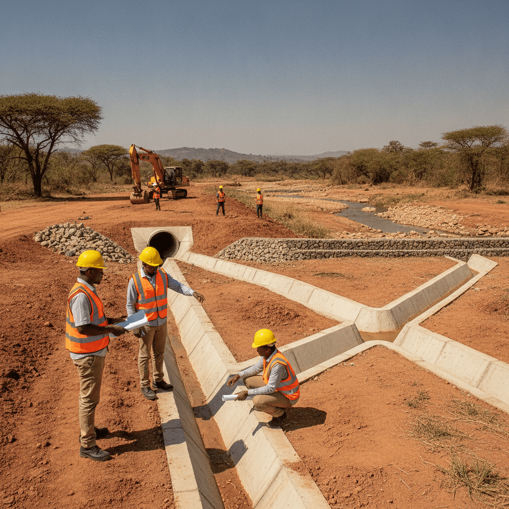
Engineering Riparian and Floodplain Sites in Kenya
Building within or adjacent to Kenya’s rivers, lakes, and coastal areas presents a unique set of engineering challenges and regulatory requirements. These sensitive zones, crucial for ecological balance and natural flood management, demand meticulous planning, specialized design, and strict adherence to environmental and construction standards. Developers and engineers must navigate complex hydrological conditions, soil instabilities, and a stringent legal framework to ensure the safety, sustainability, and compliance of any structure in these vulnerable locations. Neglecting these considerations can lead to severe structural failures, environmental degradation, and significant legal repercussions.
Environmental route affects programme and cost — screen early if site or scale triggers EMCA. See NEMA EIA checker, EIA services, and EHS hub.
Spillways, culverts, and estate layout need defensible peak-flow data. Read hydrological & flood assessment, dam engineering, and civil stormwater design for on-site drainage.
Understanding Riparian and Floodplain Zones in Kenya
Riparian zones are the transitional areas between land and water bodies, encompassing the vegetation and soil immediately adjacent to rivers, streams, lakes, and the coastline. These zones are ecologically vital, filtering pollutants, stabilizing banks, providing habitat for diverse species, and regulating water temperature. Floodplains, on the other hand, are low-lying areas adjacent to rivers that are naturally inundated during periods of high water flow. They serve as natural reservoirs, temporarily storing floodwaters and reducing downstream flood peaks. In Kenya, both riparian zones and floodplains are under increasing pressure from development, necessitating a clear understanding of their characteristics, associated risks, and the stringent regulatory framework governing construction within them.
Construction activities in these areas face inherent risks. Riverbank erosion and scour are significant threats, particularly during heavy rainfall seasons common in regions like the Lake Victoria basin or along the Tana River. Unstable soil conditions, such as the expansive black cotton soils prevalent in areas like Kajiado or the highly permeable alluvial deposits found along many riverbeds, can lose bearing capacity when saturated, leading to differential settlement or structural failure. Direct inundation from floods poses immediate risks to life and property, while the long-term effects of water saturation can compromise the durability of building materials and foundations. Beyond structural integrity, construction in these zones can lead to irreversible environmental damage, including habitat destruction, water pollution from sediment runoff, and disruption of natural hydrological processes.
The regulatory landscape in Kenya is designed to mitigate these risks. The National Environment Management Authority (NEMA), under the Environmental Management and Coordination Act (EMCA), plays a pivotal role. NEMA mandates Environmental Impact Assessments (EIAs) for all projects in sensitive ecosystems, including riparian and floodplain areas. Critically, NEMA guidelines specify minimum buffer zones: generally 6 meters from riverbanks and 30 meters from lakeshores or the high-water mark of the Indian Ocean. These buffers can vary based on the classification and ecological significance of the water body. The Water Resources Authority (WRA), guided by the Water Act 2016, also issues permits for any construction, abstraction, or discharge affecting water resources and their associated land. Furthermore, county governments, through their physical planning departments, integrate NEMA and WRA requirements into their building plan approval processes. Developers must secure approvals from the relevant county government, which often entails demonstrating compliance with these national environmental and water resource regulations. For detailed guidance on local procedures, understanding the nuances of county building plan approval Kenya
| Common Oversight | Recommended Practice |
|---|---|
| Underestimating flood recurrence intervals and peak flow rates. | Commissioning detailed hydrological studies to establish appropriate design flood levels (e.g., 100-year flood event). |
| Ignoring the 6-metre riparian buffer during site layout. | Strictly adhering to NEMA’s minimum setback requirements and incorporating ecological restoration within the buffer. |
| Failing to conduct comprehensive geotechnical investigations in saturated soils. | Performing extensive boreholes, CPTs, and laboratory tests to inform deep foundation design and soil improvement. |
| Assuming standard foundation solutions for expansive clays or alluvial deposits. | Designing specialized foundations (e.g., piled foundations, raft foundations with stiffening beams) suitable for variable soil conditions. |
| Proceeding with construction without a valid NEMA Environmental Impact Assessment (EIA) license. | Securing all necessary environmental approvals and development permits prior to any ground-breaking activities. |
is essential. Non-compliance with these regulations can result in severe penalties, including demolition orders, substantial fines, and legal prosecution, underscoring the necessity for professional guidance from the outset.
Site Assessment and Engineering Design for Water-Adjacent Projects
Developing safe and compliant structures in riparian and floodplain areas requires a multi-faceted approach to site assessment and engineering design. The initial phase involves a comprehensive site investigation that goes beyond standard geotechnical surveys to incorporate detailed hydrological and environmental studies. A topographical survey is fundamental, accurately mapping the site’s contours, existing water bodies, and critical elevations relative to historical flood levels. This data forms the basis for understanding potential inundation depths and flow paths.
A detailed geotechnical investigation is paramount. This involves drilling boreholes, excavating trial pits, and conducting in-situ tests like Standard Penetration Tests (SPT) or Cone Penetration Tests (CPT) to characterize soil profiles. Engineers must identify the presence of challenging soil types, such as highly plastic black cotton soils, which exhibit significant volume changes with moisture content, or loose alluvial deposits prone to liquefaction under seismic loading, a concern in certain parts of the Rift Valley. Crucially, groundwater levels and their seasonal fluctuations must be accurately determined, as they directly impact foundation design, excavation stability, and the potential for buoyancy or hydrostatic pressure on subterranean structures.
Simultaneously, a thorough hydrological and hydraulic study is indispensable. This typically involves analyzing historical rainfall data, assessing the upstream catchment area, and conducting flood frequency analyses (e.g., determining the 50-year or 100-year flood event). Hydraulic modeling is employed to predict flow velocities, water depths, and potential scour around proposed structures during design flood events. This helps in understanding the dynamic forces that structures might be subjected to. The expertise of a qualified hydrologist is critical in this phase to ensure accurate flood risk assessment and to inform appropriate flood mitigation strategies.
Based on these assessments, the engineering design phase focuses on developing resilient and appropriate solutions. For foundations, deep foundations such as bored or driven piles are often preferred in areas with unstable or low bearing capacity soils, extending to competent strata beneath the floodplain deposits. Raft foundations may be considered, often in conjunction with ground improvement techniques, to distribute loads over a larger area and mitigate differential settlement. During construction, meticulous excavation and dewatering plans are essential to manage groundwater and ensure the stability of excavations.
Erosion protection and scour countermeasures are integral to the design. Hard armouring techniques, including gabions, riprap, and concrete mattresses, are commonly used to stabilize riverbanks and protect foundations from the erosive forces of flowing water. In suitable contexts, bioengineering solutions, involving the strategic planting of vegetation like vetiver grass or indigenous trees, can provide effective long-term bank stabilization while enhancing ecological value. For structures like bridge piers, cut-off walls and aprons are critical to prevent localized scour. Structural design must also account for hydrostatic pressure on basement walls and buoyancy effects on foundations in high groundwater areas. Material selection is also critical; for instance, in coastal regions like Mombasa, materials must be chosen for their resistance to saline corrosion, a key consideration detailed in guides such as Structural engineer Mombasa — coastal construction guide. Finally, integrated stormwater management plans, incorporating features like permeable pavements and retention ponds, are vital to control runoff, minimize downstream impacts, and protect water quality.
Constructing within riparian and floodplain zones in Kenya demands a specialized engineering approach that prioritizes resilience against hydrological events and long-term environmental sustainability. The design process must integrate comprehensive site assessments with innovative structural and hydraulic solutions to safeguard against inundation, erosion, and structural instability. A foundational understanding of local hydrology, geology, and climatic patterns is indispensable for any project in these sensitive areas.
The initial phase involves rigorous hydrological and hydraulic analyses to map flood risks. This includes establishing the 100-year flood plain, determining peak flood levels, flow velocities, and understanding flood duration. Engineers utilize historical data, rainfall patterns, and topographical surveys to model potential flood scenarios. This information directly informs design decisions, such as minimum finished floor levels and the required freeboard above anticipated flood heights. Simultaneously, comprehensive geotechnical investigations are crucial. These studies assess soil bearing capacity, susceptibility to liquefaction under saturated conditions, and erosion potential, especially relevant in areas with expansive soils like black cotton found along river basins in regions such as the Athi River in Machakos and Kajiado counties. The presence of such soils necessitates deep foundation systems or ground improvement techniques to mitigate differential settlement and instability.
Structural designs for floodplain construction often incorporate elevated foundations, such as stilt, pier, or pile foundations, to lift the habitable spaces above projected flood levels. This approach allows floodwaters to pass beneath the structure with minimal impact. Materials selected must be resistant to water damage, corrosion, and biological growth, with reinforced concrete and treated masonry being common choices. For structures in coastal floodplains, such as those found in Mombasa, considerations extend to saline water corrosion and tidal influences, necessitating specialized concrete admixtures and protective coatings. Structural engineers in Mombasa, for instance, are adept at integrating these specific requirements into their designs.
Effective stormwater management and drainage systems are integral to floodplain resilience. Designs should minimize impervious surfaces, promoting natural infiltration through permeable paving, swales, and bio-retention ponds. These measures help reduce runoff volume and velocity, mitigating localized flooding and erosion. Integration of green building design principles, such as rainwater harvesting and sustainable drainage systems (SuDS), further enhances the project’s environmental performance and resilience.
Successful floodplain construction requires seamless collaboration between civil engineers, structural engineers, hydrologists, environmental specialists, and urban planners. Early engagement of all relevant disciplines ensures a holistic design that addresses all aspects of flood risk, environmental impact, and regulatory compliance from project inception.
The following steps outline a typical process for developing a flood-resilient engineering design:
- Site Reconnaissance and Data Collection: Conduct initial site visits, collect existing topographical maps, hydrological data, soil reports, and environmental records.
- Hydrological and Hydraulic Analysis: Perform detailed studies to determine flood levels, flow paths, velocities, and potential inundation areas for various return periods (e.g., 50-year, 100-year floods).
- Geotechnical Investigation: Execute boreholes, trial pits, and laboratory testing to understand subsurface conditions, soil properties, and groundwater levels, especially in areas with challenging soil types.
- Conceptual Design Alternatives: Develop multiple design options, considering different foundation types, building elevations, and flood protection strategies, evaluating their technical feasibility and environmental implications.
- Detailed Engineering Design: Finalize structural drawings, foundation designs, material specifications, and architectural plans, ensuring all components meet or exceed relevant building codes and flood resilience standards.
- Drainage and Erosion Control Design: Plan comprehensive stormwater management systems, including surface and subsurface drainage, erosion protection measures, and landscaping to manage water flow effectively.
- Environmental Impact Assessment (EIA) Integration: Incorporate recommendations from the EIA process into the design, ensuring compliance with environmental regulations and minimizing ecological disruption.
- Risk Assessment and Mitigation Strategies: Review the completed design against identified flood risks, develop contingency plans, and refine design elements to enhance safety and long-term performance.
Building in riparian and floodplain areas in Kenya is subject to a stringent regulatory framework designed to protect natural ecosystems, ensure public safety, and prevent environmental degradation. Navigating these approvals requires a thorough understanding of national and county-level legislation, along with strategic engagement with various regulatory bodies. Non-compliance can lead to severe consequences, including demolition orders, significant fines, and project delays.
The National Environment Management Authority (NEMA) plays a pivotal role in projects within or near water bodies. An Environmental Impact Assessment (EIA) is almost always mandatory for construction in riparian and floodplain zones. This process involves a comprehensive study of the project’s potential environmental effects and the development of an Environmental Management Plan (EMP) to mitigate adverse impacts. NEMA’s approval is a critical prerequisite for obtaining other county-level permits. For instance, projects along the Nairobi River Basin or near Lake Victoria in Kisumu must demonstrate adherence to strict riparian buffer zones, typically 6 meters from the highest flood mark, or up to 30 meters for major rivers and lakes, as per NEMA guidelines.
County governments are responsible for physical planning and issuing building permits. This involves reviewing architectural and structural drawings, ensuring compliance with local zoning ordinances, building codes, and urban development plans. The county building plan approval Kenya process requires detailed submissions, including site plans, building plans, drainage plans, and often, an approved EIA report. Specific county departments, such as Physical Planning, Lands, and Public Health, will review different aspects of the proposal.
For example, in Nairobi, any construction in areas designated as floodplains, like parts of South B or informal settlements along rivers, faces intense scrutiny. Projects must demonstrate how they will not exacerbate flooding upstream or downstream and how they are resilient to potential inundation. In Mombasa, coastal floodplains face additional considerations related to tidal surges and saltwater intrusion, requiring specific engineering solutions and environmental safeguards. In semi-arid counties like Kajiado, construction near seasonal rivers or ‘ephemeral streams’ still requires careful planning to manage flash flood risks and protect sensitive dryland ecosystems.
The documentation required for approval typically includes:
- Approved Environmental Impact Assessment (EIA) report from NEMA.
- Detailed architectural drawings stamped by a registered architect.
- Structural engineering drawings and calculations stamped by a registered structural engineer.
- Hydrological and hydraulic reports, including flood risk assessments.
- Geotechnical investigation reports.
- Drainage and stormwater management plans.
- Land ownership documents (title deed, rates clearance certificate).
- Proof of professional indemnity insurance for all engaged consultants.
Skipping professional input or attempting to bypass the regulatory process carries significant risks. Structures built without proper approvals are considered illegal and are vulnerable to demolition by county authorities or NEMA, particularly during enforcement campaigns. Furthermore, such structures often lack the necessary resilience, posing serious safety hazards to occupants and adjacent properties during flood events. The financial implications of rectifying non-compliant structures or facing legal penalties far outweigh the initial investment in professional engineering and regulatory compliance.
Developing infrastructure within riparian zones and floodplains in Kenya presents a complex array of engineering challenges and regulatory hurdles. These areas, inherently defined by their proximity to water bodies and susceptibility to inundation, demand a meticulous approach to planning, design, and construction. Ignoring the unique hydrological, geotechnical, and ecological characteristics of these sensitive environments can lead to significant safety risks, environmental degradation, and severe financial and legal repercussions.
The primary risks associated with construction in riparian and floodplain areas are multi-faceted. Hydrologically, structures are exposed to increased flood velocities, which can induce severe scour around foundations and bridge piers, leading to structural instability. Erosion of riverbanks, especially during peak flow events, can undermine adjacent structures, roads, and utilities. Sediment deposition can alter hydraulic profiles, reducing the carrying capacity of waterways and exacerbating future flooding. Geotechnical risks are equally critical; saturated soils, common in floodplains, are prone to reduced bearing capacity and increased compressibility. Expansive soils like black cotton, prevalent in areas such as Kisumu’s lowlands or parts of Kajiado, exhibit significant volume changes upon wetting and drying, posing a severe threat to shallow foundations. In coastal floodplains, such as those found in Mombasa, the combined effects of high water tables, saline intrusion, and potential liquefaction during seismic events necessitate specialized foundation design and material selection to mitigate corrosion and structural compromise. Engineers designing in these regions must consider the long-term interaction of groundwater, tidal influences, and storm surge, as detailed in guides for coastal construction. For further insights into building in such environments, refer to the structural engineer Mombasa — coastal construction guide.
Kenya’s regulatory framework, primarily driven by the National Environment Management Authority (NEMA) under the Environmental Management and Co-ordination Act (EMCA), imposes strict guidelines on development near water bodies. A fundamental requirement is the establishment of a minimum setback distance, typically 6 metres from the highest watermark or riverbank, for any permanent structures. This riparian reserve is crucial for ecological functions and as a natural buffer against floods. Beyond NEMA, county governments, through their physical planning departments, enforce specific zoning regulations and development control plans. For instance, Nairobi County has specific bylaws governing construction along the Nairobi River and its tributaries, often requiring detailed Environmental Impact Assessments (EIAs) or Environmental Audits (EAs) for projects in sensitive areas. Compliance involves not only obtaining development permission but also adhering to conditions stipulated in the environmental license, which may include specific flood mitigation measures, waste management plans, and ecological restoration efforts.
The foresight applied during the initial planning and design phases of projects within sensitive riparian and floodplain environments is paramount to ensuring both structural resilience and ecological stewardship.
Failing to adhere to these compliance requirements carries severe consequences. Projects may face stop orders, demolition notices, and significant fines, leading to substantial financial losses and protracted legal battles. More critically, non-compliant structures pose inherent safety risks to occupants and the surrounding community. Inadequate flood protection can result in structural collapse, damage to essential infrastructure, and displacement. Environmentally, unauthorized or poorly executed development can degrade water quality, destroy critical habitats, and disrupt natural hydrological processes, often impacting downstream communities.
| Key Assessment Area | Engineering Best Practice |
|---|---|
| Hydrological Study | Comprehensive flood frequency analysis and hydraulic modeling to predict flood levels and flow dynamics. |
| Geotechnical Investigation | Detailed boreholes, in-situ tests, and laboratory analysis to characterize soil profiles, groundwater, and stability under saturated conditions. |
| Environmental Impact | Thorough EIA to identify potential ecological disruptions and propose mitigation measures in line with NEMA guidelines. |
| Regulatory Compliance | Early engagement with NEMA, WRA, and county planning departments to ensure all permits and approvals are secured. |
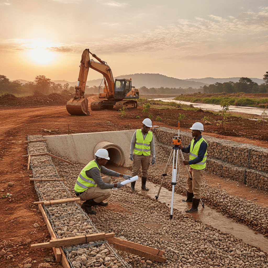
Engineering Design for Floodplain Resilience
| Common Oversight in Approvals | Recommended Practice for Compliance |
|---|---|
| Delaying NEMA engagement until late in the project cycle. | Initiate NEMA Environmental Impact Assessment (EIA) process at the earliest conceptual design stage. |
| Submitting incomplete or generic hydrological and geotechnical reports. | Provide comprehensive, site-specific hydrological and geotechnical studies conducted by qualified specialists. |
| Ignoring local county physical planning requirements and zoning ordinances. | Thoroughly review county integrated development plans and zoning maps for the project area before design. |
| Failing to incorporate a sufficient riparian buffer zone into the site layout. | Strictly adhere to NEMA’s prescribed riparian buffer zones from the highest flood mark or water body edge. |
| Proceeding with construction before all necessary permits are officially granted. | Ensure all national and county permits, including NEMA and building approvals, are obtained in writing. |
| Assuming standard building codes apply without special flood resilience measures. | Integrate specific flood-resistant design principles and materials, supported by engineering calculations. |
Navigating Regulatory Approvals and Compliance
Navigating Risks and Compliance in Riparian and Floodplain Development
Frequently Asked Questions
What defines a riparian or floodplain area in Kenya?
In Kenya, a riparian area typically refers to the land adjacent to a river, stream, lake, or other water body, extending to a defined distance from its highest watermark. NEMA regulations generally stipulate a minimum 6-metre riparian reserve, though this can vary based on the water body’s size and ecological significance. Floodplains are low-lying areas adjacent to rivers or lakes that are subject to periodic inundation during flood events. These areas are characterized by specific hydrological and geomorphological features, often with alluvial soils deposited by historical floods. Identifying these zones accurately requires expert hydrological surveys and interpretation of topographical data, considering historical flood levels and potential climate change impacts.
What are the critical initial steps for a developer considering building near a water body?
The very first step for any developer should be to engage qualified environmental and engineering professionals. This includes a hydrological engineer to assess flood risk and define riparian boundaries, a geotechnical engineer to investigate soil conditions, and an environmental expert to guide the Environmental Impact Assessment (EIA) process. Early site surveys are crucial to understand the topography, existing drainage patterns, and proximity to the water body. Simultaneously, a developer must consult the relevant county physical planning department and NEMA to understand specific zoning regulations, development controls, and permit requirements applicable to the site. This proactive approach helps identify potential constraints and informs preliminary design decisions.
How do soil conditions in Kenyan floodplains affect foundation design?
Soil conditions in Kenyan floodplains are highly variable and pose significant challenges for foundation design. Common soil types include expansive black cotton soils, particularly in Western Kenya and parts of the Rift Valley, which undergo significant volume changes with moisture fluctuations, requiring deep foundations or ground improvement. Alluvial deposits, often loose and compressible, necessitate careful evaluation of settlement potential and bearing capacity. High water tables are almost universal in floodplains, affecting excavation stability and requiring dewatering or specialized construction techniques. Engineers must conduct thorough geotechnical investigations, including boreholes and laboratory testing, to characterize these soils. Designs often incorporate deep foundations like piles or piers, raft foundations, or ground improvement techniques such as compaction or dynamic consolidation to achieve adequate bearing capacity and mitigate settlement or heave.
What is the typical duration for obtaining necessary approvals for riparian construction?
The duration for obtaining necessary approvals for riparian construction in Kenya can vary significantly, ranging from several months to over a year, depending on the project’s scale, complexity, and specific location. The most time-consuming component is often the NEMA Environmental Impact Assessment (EIA) process, which involves public participation, expert review, and agency consultations. This alone can take 3 to 6 months. Following NEMA approval, county building plan approvals are required, which can take an additional 2 to 4 months, depending on the county’s administrative efficiency and the completeness of submitted documentation. Any appeals or requests for additional information during these stages can extend timelines considerably. Early engagement with authorities and comprehensive, well-prepared submissions are key to streamlining the process.
Key Takeaways
- Regulatory Compliance is Paramount: Strict adherence to NEMA regulations, the Water Act, and specific county by-laws is non-negotiable for any development near water bodies or within floodplains in Kenya.
- Thorough Site Investigations are Essential: Comprehensive geotechnical and hydrological studies must be conducted to accurately assess soil stability, groundwater levels, flood risk, and water flow dynamics, informing resilient design.
- Risk Mitigation Through Design: Employing flood-resilient design strategies, such as elevated foundations, use of water-resistant materials, permeable paving, and effective drainage systems, is crucial for long-term structural integrity and safety.
- Environmental Sensitivity in Planning: Designs must integrate ecological considerations, actively working to protect natural habitats, maintain biodiversity, and ensure minimal adverse impact on riparian ecosystems and water quality.
- Professional Engineering Input is Indispensable: Engaging qualified structural, civil, and hydrological engineers from the project’s inception ensures that designs are safe, compliant with all regulations, and sustainable for the specific site conditions.
- Integrated Planning and Multidisciplinary Approach: Successful projects in these sensitive zones require a coordinated effort, combining expertise from civil engineering, structural engineering, environmental science, and urban planning.
- Long-Term Sustainability and Maintenance: Focus on robust materials and construction methods that can withstand harsh environmental conditions, reduce erosion, and minimize future maintenance burdens and operational costs.
- Strict Avoidance of Encroachment: Understanding and strictly respecting defined riparian reserves and floodplain boundaries is critical to prevent legal disputes, environmental degradation, and significant safety hazards associated with natural water flows.
Navigating the complexities of riparian and floodplain construction in Kenya demands a deep understanding of local regulations, environmental factors, and specialized engineering principles. From the initial feasibility studies and detailed hydrological assessments to the design of resilient structures and the intricate process of obtaining regulatory approvals from bodies like NEMA and relevant county authorities, every phase requires meticulous attention to detail. Ensuring the long-term safety, structural integrity, and environmental sustainability of your project is not merely a compliance issue but a fundamental commitment to responsible development. Engaging with qualified and experienced engineering professionals from the earliest stages of planning can significantly mitigate potential risks, streamline the often-challenging approval processes, and guarantee that your project adheres to the highest standards of environmental stewardship and building safety. For comprehensive, expert guidance and professional consultation on your next project situated in challenging riparian or floodplain environments across Kenya, reaching out to experienced engineering consultants is a prudent first step towards success.
Contact a qualified engineering consultant:
Phone: +254 719 532 233
Email: info@Cadreatech.com
Website: Cadreatech.com
