
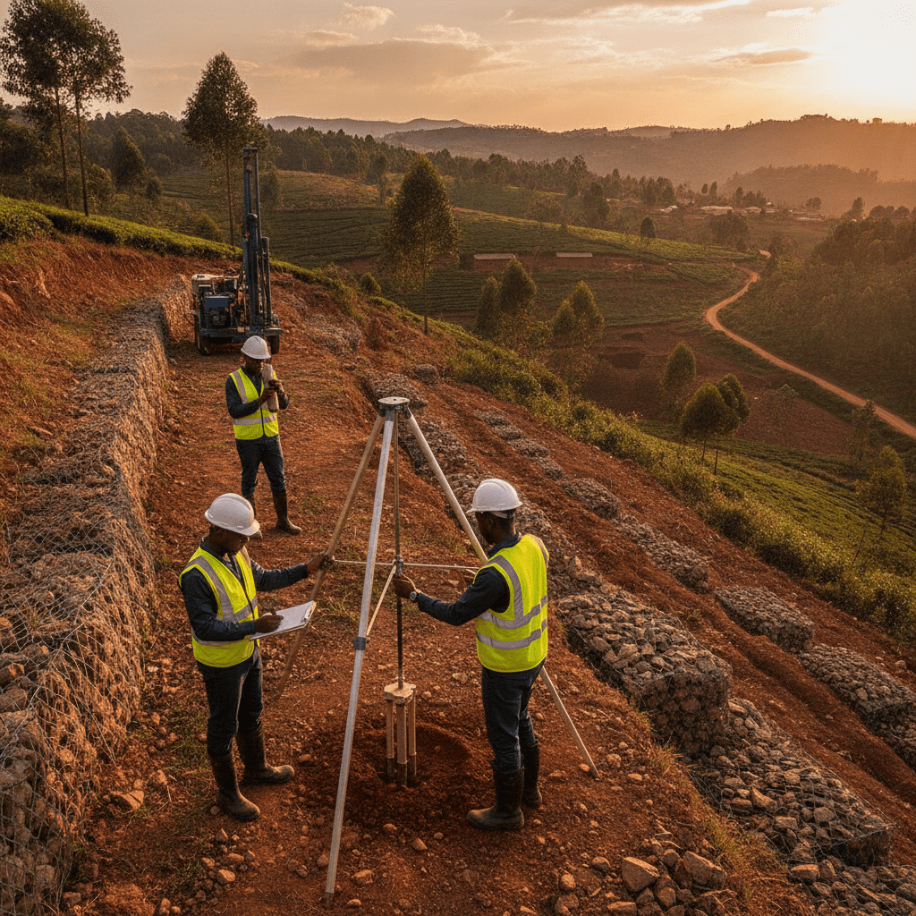
Slope Stability Assessment: Safeguarding Hillside Developments in Kenya
Kenya’s diverse topography, ranging from the dramatic Rift Valley escarpments to the undulating coastal plains and central highlands, presents unique opportunities and challenges for infrastructure development. With increasing pressure for urbanisation and land use, construction often extends to hilly and mountainous terrains. However, these environments are inherently susceptible to slope instability, posing significant risks to structures, human life, and the environment. Understanding and proactively addressing these risks through comprehensive slope stability assessments is paramount for ensuring the safety and longevity of any hillside development project.
Before you size footings or specify a slab, confirm what is under your site. See our geotechnical services, soil test cost guide, and foundation types in Kenya.
Understanding Slope Instability and Its Triggers in Kenya
Slope instability refers to the downward movement of a mass of soil or rock under gravitational forces. This phenomenon can manifest in various forms, including slow creep, sudden landslides, rockfalls, and debris flows, each with distinct characteristics and destructive potential. In Kenya, several factors converge to heighten the risk of such events, particularly in regions like Murang’a, Elgeyo Marakwet, West Pokot, and parts of the Taita Taveta hills, which frequently experience heavy rainfall and seismic tremors.
Geological and geotechnical factors play a crucial role. The inherent strength of the soil and rock materials, their stratification, the presence of faults or discontinuities, and the groundwater regime are primary determinants of slope stability. For instance, areas with highly weathered rocks or weak soil layers are naturally more prone to failure. Kenya’s varied geology includes expansive soils like black cotton soil, which can exhibit significant volume changes with moisture content fluctuations, reducing shear strength and increasing instability when saturated on slopes. Similarly, highly fractured rock masses, common in the Rift Valley, can lead to dangerous rockfalls if not properly assessed and mitigated. For detailed insights into specific soil challenges, engineers often refer to comprehensive resources on Professional Black Cotton Soil Assessment in Kenya for Long-Lasting Foundations.
Climatic conditions, especially prolonged and intense rainfall, are a dominant trigger for slope failures across Kenya. Heavy downpours saturate the ground, increasing the pore water pressure within the soil and rock mass, which in turn reduces their effective shear strength. This hydrostatic pressure can act as a destabilising force, particularly on slopes already at their limit of equilibrium. The El Niño phenomenon, which periodically brings torrential rains, consistently correlates with an uptick in landslide incidents, especially in deforested or poorly managed hillside areas. Human activities further exacerbate these natural vulnerabilities. Improper excavation, uncontrolled cutting of slopes for roads or foundations, indiscriminate deforestation, and inadequate drainage systems can all disrupt the natural equilibrium of a slope, significantly increasing its susceptibility to failure. The cumulative effect of these factors necessitates a rigorous and professional approach to evaluating the stability of any slope intended for development.
Warning: Ignoring Slope Stability Assessments
Neglecting a professional slope stability assessment before commencing hillside development can lead to catastrophic consequences. These include structural collapse of buildings, damage to infrastructure, loss of life, severe environmental degradation, and significant financial liabilities. Regulatory compliance also mandates such assessments for many developments on challenging terrains, and non-compliance can result in project delays, hefty fines, or demolition orders.
| Common Oversight in Slope Development | Recommended Practice for Stability |
|---|---|
| Assuming all slopes are stable if no visible cracks exist. | Conducting a detailed geotechnical investigation regardless of initial appearance. |
| Cutting slopes too steeply without expert analysis or support. | Designing cut and fill slopes to safe angles determined by soil mechanics. |
| Discharging stormwater directly onto or near the slope face. | Implementing controlled drainage systems that divert water away from critical areas. |
| Relying on vegetation alone for long-term structural stability. | Combining bio-engineering with structural solutions where significant risk exists. |
| Ignoring minor signs of ground movement or water seepage. | Initiating immediate professional assessment upon detection of any anomaly. |
The Comprehensive Process of Slope Stability Assessment
A thorough slope stability assessment is a multi-faceted process that integrates desk studies, field investigations, laboratory testing, and advanced analytical methods to evaluate the safety of a slope and recommend appropriate mitigation measures. This systematic approach ensures that all potential failure mechanisms are identified and addressed, providing a robust foundation for safe and sustainable development.
The process typically commences with a Desk Study and Site Reconnaissance. This initial phase involves reviewing existing geological maps, topographical surveys, historical rainfall data, and any previous geotechnical reports for the area. A visual inspection of the site is then conducted to identify existing signs of instability such as tension cracks, bulging ground, leaning trees, or evidence of past landslides. This helps in understanding the site’s geomorphology and planning subsequent detailed investigations.
Next, Subsurface Investigations are planned and executed. This is a critical step that involves drilling boreholes, excavating trial pits, and conducting in-situ tests to characterise the subsurface conditions. Standard Penetration Tests (SPT) are commonly performed in boreholes to assess soil density and strength, while Cone Penetration Tests (CPT) provide continuous data on soil stratigraphy and properties. Undisturbed soil samples are collected from various depths for laboratory testing. For rock slopes, core drilling is used to retrieve rock samples for analysis of strength and discontinuity characteristics. The depth and number of boreholes are determined based on the site’s complexity, proposed structure loads, and local geological conditions, often extending to depths of 15-30 meters or more for significant structures.
Laboratory Testing of the collected soil and rock samples is essential to determine their engineering properties. Key tests include soil classification (Atterberg limits, particle size distribution), shear strength parameters (direct shear, triaxial compression tests), consolidation characteristics, and permeability. These parameters are crucial inputs for numerical stability analyses. Simultaneously, Groundwater Monitoring is often initiated using piezometers installed in boreholes to measure the groundwater table fluctuations, which significantly influence effective stress and slope stability.
The collected data from field and laboratory tests are then used for Stability Analysis. Engineers employ various analytical methods, ranging from limit equilibrium methods (e.g., Fellenius, Bishop, Janbu, Spencer) to more advanced numerical methods like finite element or finite difference analysis. These analyses calculate a Factor of Safety (FoS) for the slope, which indicates its stability margin against failure. A FoS greater than 1.0 is generally considered stable, but typically a higher value (e.g., 1.3 to 1.5) is targeted for permanent structures to account for uncertainties and potential future changes. The analysis considers different potential failure surfaces and critical loading conditions, including seismic effects and rainfall infiltration.
The culmination of the assessment is a comprehensive Engineering Report, which details the site conditions, investigation methods, test results, stability analysis, and a clear set of recommendations. These recommendations may include slope reprofiling, improved drainage systems, the construction of retaining walls, soil nailing, rock bolting, or specific foundation designs. For structures requiring significant earth retention, the report often includes detailed considerations that inform retaining wall design for slope stability, drainage, and failure prevention.
This rigorous process ensures that potential risks are quantified, and appropriate, cost-effective mitigation strategies are developed to safeguard the development for its entire design life.
A comprehensive slope stability assessment in Kenya is a multi-stage engineering process, meticulously designed to identify potential failure mechanisms and quantify the associated risks. This involves a blend of desk-based research, rigorous fieldwork, laboratory testing, and advanced analytical modelling. The objective is to provide actionable recommendations for safe development and mitigation measures on sloped terrains, crucial for preventing catastrophic events like landslides.
Engineers undertaking such assessments typically follow a structured methodology to ensure all critical factors are considered. This process is essential for any proposed development on or near natural or engineered slopes, particularly in areas prone to geological hazards, such as the Great Rift Valley escarpments or the steep hillsides of counties like Murang’a and Elgeyo-Marakwet.
Here is a typical step-by-step process for conducting a professional slope stability assessment:
- Desk Study and Preliminary Data Collection: This initial phase involves reviewing existing geological maps, topographical surveys, historical rainfall data, satellite imagery, and any previous geotechnical reports for the area. Understanding the regional geology, including fault lines, rock formations, and historical landslide occurrences, provides crucial context.
- Site Reconnaissance and Visual Inspection: A qualified engineer conducts a detailed visual inspection of the site. This involves observing existing slope conditions, identifying signs of instability (e.g., tension cracks, bulging, seepage, displaced vegetation), assessing drainage patterns, and noting any existing structures or infrastructure that might be affected. This step helps in planning the subsequent detailed investigations.
- Geotechnical Field Investigations: This is the most critical data collection phase. It involves intrusive investigations such as drilling boreholes, excavating test pits, and performing in-situ tests.
- Boreholes: Drilled to extract soil and rock samples at various depths and to install piezometers for monitoring groundwater levels. These are crucial for understanding subsurface stratigraphy.
- Test Pits: Provide a direct visual inspection of soil profiles to shallower depths, allowing for detailed logging of soil types, moisture content, and the presence of any weak layers or discontinuities.
- In-situ Tests: Standard Penetration Tests (SPT) provide an indication of soil density and strength, while Cone Penetration Tests (CPT) offer continuous profiling of soil properties. Dynamic Cone Penetrometer (DCP) tests are also commonly used for rapid assessment of shallow soil strength.
For sites with problematic soils, such as expansive black cotton soil, specialised investigations may be required to assess their unique behaviour. Readers can learn more about Professional Black Cotton Soil Assessment in Kenya for Long-Lasting Foundations.
- Laboratory Testing of Samples: Collected soil and rock samples are transported to an accredited laboratory for a suite of tests. These include classification tests (e.g., Atterberg limits, particle size distribution), strength tests (e.g., direct shear, triaxial compression to determine cohesion and angle of internal friction), and permeability tests. These parameters are fundamental inputs for numerical analysis.
- Geotechnical Analysis and Modelling: Using the data from field and laboratory investigations, engineers perform numerical analyses to evaluate the slope’s stability. Common methods include:
- Limit Equilibrium Methods: Such as the Bishop, Janbu, or Spencer methods, which calculate a Factor of Safety (FoS) against failure for various potential slip surfaces. An FoS greater than 1.5 is generally considered stable for permanent slopes, but this can vary based on risk tolerance and local codes.
- Finite Element Analysis (FEA): Advanced methods that can model complex geometries, material behaviour, and pore water pressure conditions more accurately, providing insights into deformation patterns and stress distribution.
Analysis considers different scenarios, including static conditions, rapid drawdown of water levels, and seismic loading, to assess the most critical failure mode.
- Reporting and Recommendations: The culmination of the assessment is a detailed geotechnical report. This report typically includes a description of the site and geology, methodology, findings from field and lab tests, results of stability analyses (including FoS values), identification of potential failure mechanisms, and a comprehensive set of recommendations. Recommendations may include slope re-profiling, stabilisation techniques (e.g., soil nailing, ground anchors), drainage improvements, and the design of retaining wall design Kenya — slope stability, drainage, and failure prevention. The report also specifies monitoring requirements and construction considerations.
The stability of a slope is a complex interplay of geological, hydrological, and environmental factors, often exacerbated by human activities. Understanding these critical factors is paramount for any slope stability assessment in Kenya, as they directly dictate the scope, methodology, and ultimately, the robustness of the engineering solutions proposed. The diverse topography and geological conditions across Kenya, from the coastal plains to the central highlands and the Rift Valley, mean that specific factors will vary in prominence depending on the site’s location.
Geological Conditions: The underlying geology is the primary determinant of slope stability. Factors include the type of soil or rock, its strength properties (cohesion, angle of internal friction), the presence of weak layers, discontinuities (faults, joints, bedding planes), and the dip and strike of rock strata relative to the slope face. For instance, slopes composed of highly weathered shale or expansive clays like black cotton soil are inherently more susceptible to failure than those in competent granitic rock. In regions like Mombasa, the presence of coral limestone can introduce unique stability challenges related to dissolution and karstification.
Hydrological Factors: Water is perhaps the most significant destabilising agent for slopes. Both surface water and groundwater play critical roles:
- Rainfall Infiltration: Prolonged heavy rainfall, common during Kenya’s long and short rainy seasons, can saturate soils, increasing their unit weight and reducing shear strength due due to elevated pore water pressures. This is a common trigger for landslides in areas like the Aberdare Ranges.
- Groundwater Levels: High groundwater tables reduce the effective stress within the soil mass, thereby decreasing its shear strength. Seepage forces can also exert destabilising pressure on the slope face.
- Surface Runoff: Uncontrolled surface runoff can lead to erosion of the slope face, toe scour, and the formation of gullies, progressively undermining stability.
Slope Geometry: The height, angle, and overall configuration of a slope directly influence its stability. Steeper and taller slopes inherently have a lower factor of safety compared to gentler, shorter ones. The presence of convex or concave slope profiles, benches, or existing tension cracks also significantly impacts the stability analysis.
Vegetation: While dense vegetation can offer some protection against shallow erosion through root reinforcement, it can also add surcharge to the slope and, in some cases, deep-rooted trees can create preferential pathways for water infiltration. The removal of vegetation, particularly large trees, can rapidly destabilise a previously stable slope by eliminating the root network that binds the soil.
Human Activity: Anthropogenic factors are frequent triggers for slope failures. These include:
- Excavation and Undercutting: Cutting into the toe of a slope for road construction, building foundations, or quarrying removes lateral support, significantly reducing stability. This is often observed in urban fringes of Nairobi and Kajiado counties where development expands onto hillsides.
- Loading: Placing heavy structures, stockpiles of material, or even excessive fill on the crest of a slope adds surcharge, increasing the driving forces for failure.
- Changes in Drainage: Altering natural drainage patterns through construction of impermeable surfaces or improper stormwater management can concentrate water flow, leading to increased infiltration and erosion.
- Vibrations: Blasting, heavy construction traffic, or seismic activity (relevant in Rift Valley areas) can induce liquefaction in susceptible soils or trigger failures in marginally stable slopes.
The scope of a slope stability assessment is tailored to these factors. For a minor cut slope in stable ground, a visual inspection and limited field tests might suffice. However, for a major development on a high, steep slope in an area with complex geology and high rainfall, an extensive program of boreholes, advanced laboratory testing, and sophisticated numerical modelling would be indispensable. Skipping a thorough assessment, or cutting corners, can lead to severe safety risks, costly remedial works, and potential legal liabilities, underscoring the importance of professional engineering input.
Ignoring potential slope instability during site development in Kenya can lead to catastrophic consequences, far beyond mere structural damage. The country’s diverse topography, coupled with varied climatic conditions and rapid urbanisation, presents unique challenges that necessitate rigorous professional black cotton soil assessment and comprehensive slope stability evaluations.
The primary risks associated with unstable slopes include the direct threat to human life, significant property damage, and long-term environmental degradation. Landslides and mass movements can destroy buildings, roads, and critical infrastructure, leading to substantial economic losses and displacement of communities. In regions like Western Kenya, particularly areas prone to heavy rainfall such as Murang’a, Elgeyo Marakwet, and parts of Kisii, historical data consistently demonstrates the devastating impact of unmitigated slope failures.
Minor cracks in foundations, subtle ground bulges, or unexplained changes in drainage patterns around a hillside property are critical warning signs. Ignoring these can lead to rapid escalation of instability, potentially resulting in catastrophic failure during heavy rainfall seasons. A prompt, qualified assessment is always advisable.
From a regulatory standpoint, adherence to established engineering standards and county development control requirements is paramount. In Kenya, local county governments, often guided by the National Construction Authority (NCA) guidelines, mandate that all hillside developments undergo a thorough geotechnical investigation and a certified structural design. An engineer’s report, detailing the slope’s stability and proposed mitigation measures, is typically a prerequisite for obtaining construction permits. Failure to comply can result in stop orders, demolition notices, and significant legal liabilities for developers and property owners.
Specific Kenyan geological and climatic factors exacerbate slope stability issues:
- Black Cotton Soil: Prevalent in areas like Kajiado and parts of Nairobi, this expansive soil type undergoes significant volume changes with moisture fluctuations. On slopes, this can lead to differential settlement and increased shear stress, compromising stability.
- Coastal Erosion: In regions such as Mombasa and Kwale, the combination of heavy rainfall, sandy soils, and coastal erosion can lead to rapid destabilisation of cliffs and embankments, particularly where developments encroach too close to the shoreline.
- Highland Rainfall: The steep terrains of the Central Highlands and Rift Valley escarpments experience intense, prolonged rainfall. This saturates the soil, increasing pore water pressure and significantly reducing soil shear strength, a common trigger for landslides.
- Anthropogenic Factors: Uncontrolled cutting of slopes for roads or foundations, improper drainage systems, and the removal of stabilising vegetation further compound natural vulnerabilities across various counties.
Effective mitigation often involves a multi-faceted approach, including robust drainage solutions, appropriate soil reinforcement techniques, and the strategic use of retaining wall design. The choice of solution depends heavily on the specific geological profile, hydrological conditions, and the geometry of the slope, all of which are identified during a professional assessment.
| Common Oversight in Hillside Development | Recommended Practice for Slope Stability |
|---|---|
| Commencing excavation without a detailed geotechnical investigation. | Conducting a comprehensive subsurface investigation to characterise soil/rock properties. |
| Ignoring existing signs of minor instability or past landslide events. | Thorough site reconnaissance and review of historical data to identify potential failure zones. |
| Inadequate surface and subsurface drainage provision. | Designing robust drainage systems to manage stormwater runoff and groundwater levels. |
| Placing excessive loads on crests of slopes or excavating at the toe. | Adhering to strict loading and excavation guidelines based on stability analysis. |
| Assuming uniform soil conditions across varied topography. | Utilising multiple investigation points and laboratory tests to account for geological variability. |
| Failing to consider seismic activity or extreme rainfall events. | Incorporating dynamic analysis and climate change projections into stability assessments. |
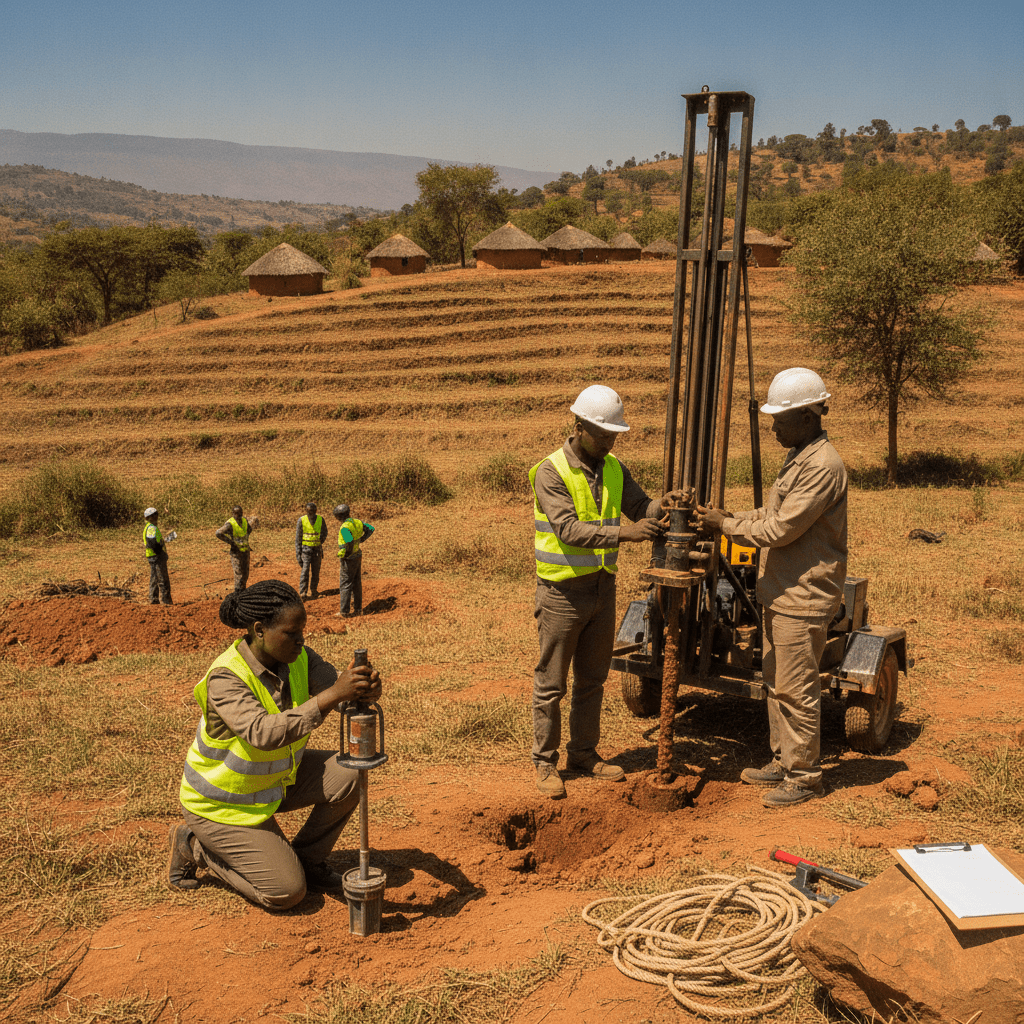
The Engineering Process of Slope Stability Assessment in Kenya
| Common Oversight in Slope Development | Recommended Practice for Stability |
|---|---|
| Ignoring existing groundwater seepage or springs on a slope. | Conducting detailed hydrogeological surveys and implementing comprehensive subsurface drainage systems. |
| Undercutting the toe of a slope without adequate retaining structures or re-profiling. | Designing appropriate retaining walls or engineered berms based on geotechnical analysis before excavation. |
| Discharging stormwater directly onto a slope face or its crest. | Implementing controlled surface water management systems, including lined drains and energy dissipators, to divert water safely. |
| Assuming uniform soil conditions across a varied slope without targeted investigations. | Executing a phased geotechnical investigation plan, adjusting test locations and depths based on initial findings and geological mapping. |
| Planting shallow-rooted or water-intensive vegetation on a slope. | Selecting deep-rooted, drought-resistant native vegetation that enhances soil binding and minimises water infiltration. |
Critical Factors Influencing Slope Stability and Assessment Scope
Risks, Regulatory Compliance, and Kenyan Context
A thorough site investigation for slope stability extends beyond visual inspection. It typically involves borehole drilling, laboratory testing of soil samples (e.g., shear strength, plasticity index), hydrogeological studies, and advanced numerical modelling to predict potential failure mechanisms and calculate factors of safety under various conditions.
Frequently Asked Questions
How often should a slope stability assessment be conducted?
A slope stability assessment is primarily crucial before any new construction or significant earthworks on or near a sloped area. However, it should also be considered after major natural events like prolonged heavy rainfall, seismic activity, or any noticeable changes in the slope’s appearance, such as new cracks or bulges. For existing structures on slopes, periodic re-evaluation, perhaps every 5-10 years, or immediately upon observing any distress, is a prudent measure, especially in areas with known geological activity or high rainfall intensity. The dynamic nature of slopes means conditions can change over time due to weathering, erosion, and human activity.
What are the visible signs of potential slope instability?
Several observable signs can indicate a slope is becoming unstable. These include the appearance of new cracks in the ground, pavements, or retaining walls, particularly if they are widening or lengthening. Look for leaning trees, utility poles, or fences that were once vertical. Bulging ground at the base of the slope, or unusual depressions and hummocks on the slope surface, are also critical indicators. Increased water seepage, especially during dry periods, or sudden changes in spring and stream flow can point to altered subsurface conditions. Lastly, doors and windows in nearby structures that suddenly stick or become misaligned can signal ground movement.
Can a slope be stabilised after initial signs of movement?
Yes, in many cases, a slope showing initial signs of movement can be successfully stabilised, but timely intervention by qualified geotechnical engineers is critical. The specific remediation strategy will depend on the cause and extent of the movement. Common stabilisation techniques include improving surface and subsurface drainage to reduce water saturation, constructing retaining structures like gabion walls, reinforced concrete walls, or soil-nailed slopes, and applying bio-engineering solutions such as planting deep-rooted vegetation. Early detection allows for less invasive and generally more cost-effective solutions compared to addressing a full-scale landslide.
What role does vegetation play in slope stability in Kenya?
Vegetation plays a dual, critical role in slope stability, particularly in Kenya’s varied environments. The root systems of plants, especially deep-rooted trees and shrubs, act as natural reinforcement, binding soil particles together and increasing the soil’s shear strength, thereby enhancing its resistance to erosion and shallow landslides. Furthermore, vegetation helps to intercept rainfall, reducing the amount of water infiltrating the soil and thus mitigating pore water pressure build-up. However, it’s also important to note that very large trees can add significant surcharge weight to a slope, and decaying root systems can create preferential pathways for water. Therefore, proper selection and management of vegetation, often as part of a broader bio-engineering solution, are essential for effective slope stabilisation.
Key Takeaways
Developing on sloping terrain in Kenya presents unique geotechnical challenges that demand meticulous planning and expert engineering input. Understanding and mitigating landslide risk is paramount for sustainable and safe hillside developments. The following points summarise critical considerations for any project involving slope stability:
- Comprehensive Geotechnical Investigation: A detailed site investigation is the foundational step for any hillside development. This includes boreholes, trial pits, and laboratory testing of soil and rock samples to accurately characterise subsurface conditions, identify weak layers, and determine hydrological influences. Ignoring this crucial initial phase can lead to catastrophic failures and significant remedial costs.
- Hydrological Analysis and Drainage Design: Water is a primary trigger for slope failure, particularly during Kenya’s intense rainy seasons. Thorough hydrological studies are essential to understand surface and subsurface water flow patterns. Effective drainage systems, including surface drains, sub-surface drains, and cut-off drains, must be meticulously integrated into the design to manage water ingress, prevent pore pressure build-up, and maintain soil stability.
- Appropriate Retention Systems: Depending on the specific site conditions, geology, and proposed development, various retention systems may be necessary to stabilise slopes. These can range from gravity walls and cantilever walls to more advanced reinforced earth structures, gabion walls, or soil nailing. The selection of the appropriate system must be based on detailed engineering analysis, considering factors like slope angle, soil strength parameters, and potential surcharge loads from structures.
- Regular Monitoring and Maintenance: Slope stability is not a static condition; it can change over time due to environmental factors or external influences. Even after construction, slopes require ongoing monitoring, particularly during and after periods of intense rainfall. Visual inspections for tension cracks, bulging, changes in vegetation, or any signs of ground movement are critical. Regular maintenance of all drainage systems is also crucial to ensure their continued effectiveness.
- Compliance with Local Regulations: Developments on sloping terrain in Kenya are subject to various county and national environmental and planning regulations. Engaging qualified professionals ensures that all designs and construction methodologies adhere to relevant building codes, environmental impact assessment requirements, and land use zoning. This proactive approach prevents future legal or safety issues and ensures long-term project viability.
- Consideration of Dynamic Factors: A robust slope stability assessment must account for dynamic factors that could impact the slope over its lifespan. These include potential seismic activity, future land use changes (e.g., increased loading from new structures, deforestation), and long-term climatic variations. A conservative design approach, incorporating appropriate safety factors, is vital to account for these uncertainties and ensure the long-term resilience of the development.
- Expert Engagement for Design and Supervision: The inherent complexity of slope stability mandates the involvement of experienced geotechnical and structural engineers from project inception through to completion. Their specialised expertise is crucial for accurate assessment, robust design, and competent construction supervision, safeguarding both the significant investment and the safety of occupants and the surrounding community.
Need Professional Engineering Guidance?
Navigating the complexities of slope stability and hillside development requires specialised expertise. For a thorough assessment, expert design, and guidance tailored to your project’s unique challenges, connect with qualified professionals.
- Phone: +254 719 532 233
- Email: info@Cadreatech.com
- Website: Cadreatech.com
Related Reading
- Professional Black Cotton Soil Assessment in Kenya for Long-Lasting Foundations
- Retaining wall design Kenya — slope stability, drainage, and failure prevention
- Change of use building Kenya — structural assessment before conversion
- Structural engineer for renovation and extension Kenya — load assessment process
- Pre-Purchase Structural Inspection Kenya
